NavVis, a leading solution provider in mobile indoor mapping, visualization, and navigation, just introduced a new add-in for Autodesk Revit.
The Revit users can use this add-in to associate their BIM models to 360 degree immersive imagery and point clouds which are captured with the NavVis mobile mapping system. This add-in makes the process simple for generating and updating obsolete BIM models to reveal the present condition of the building.
NavVis technology stands for a multipurpose reality capture solution that facilitates to instantly scan the present condition of large industrial and commercial properties and move the data on any device. The data is procured by the NavVis M6 mobile mapping system, an groundbreaking mobile mapping system that can scan indoor environments s at rapid speed.
The data is then visualized in the NavVis IndoorViewer, a browser supported software that streams the immersive panoramic images and point clouds.
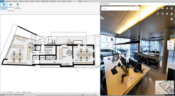
It is now possible to incorporate the NavVis IndoorViewer with Revit BIM models through this Revi add-in. With this integration of Revit and IndoorViewer, a side-by-side comparison of the BIM model can be done and the scanned state of the building can be determined distantly from a desktop.
It facilitates the users to instantly identify the changes which were made at the time of formation of the model and the present condition was captured to accelerate the process of updating BIM models. With the incorporation of BIM and IndoorViewer, data silos can’t occur and the planning errors are decreased which may happen because of outdated information.
The Revit users who install the add-in can access the added value of the NavVis IndoorViewer, which range from adding and pursuing information and mark-ups, taking measurements, determining route and online collaboration with stakeholders.
For more information, click on the following link www.navvis.com

~~~~~~~~~~~~~~~~~~~~~~~~
Published By
Rajib Dey
www.bimoutsourcing.com
~~~~~~~~~~~~~~~~~~~~~~~~
The Revit users can use this add-in to associate their BIM models to 360 degree immersive imagery and point clouds which are captured with the NavVis mobile mapping system. This add-in makes the process simple for generating and updating obsolete BIM models to reveal the present condition of the building.
NavVis technology stands for a multipurpose reality capture solution that facilitates to instantly scan the present condition of large industrial and commercial properties and move the data on any device. The data is procured by the NavVis M6 mobile mapping system, an groundbreaking mobile mapping system that can scan indoor environments s at rapid speed.
The data is then visualized in the NavVis IndoorViewer, a browser supported software that streams the immersive panoramic images and point clouds.
It is now possible to incorporate the NavVis IndoorViewer with Revit BIM models through this Revi add-in. With this integration of Revit and IndoorViewer, a side-by-side comparison of the BIM model can be done and the scanned state of the building can be determined distantly from a desktop.
It facilitates the users to instantly identify the changes which were made at the time of formation of the model and the present condition was captured to accelerate the process of updating BIM models. With the incorporation of BIM and IndoorViewer, data silos can’t occur and the planning errors are decreased which may happen because of outdated information.
The Revit users who install the add-in can access the added value of the NavVis IndoorViewer, which range from adding and pursuing information and mark-ups, taking measurements, determining route and online collaboration with stakeholders.
For more information, click on the following link www.navvis.com

~~~~~~~~~~~~~~~~~~~~~~~~
Published By
Rajib Dey
www.bimoutsourcing.com
~~~~~~~~~~~~~~~~~~~~~~~~
thank u for posting MEP F modelling
ReplyDelete