adsense analytic

Showing posts with label 3D laser scanning. Show all posts

Thursday, March 12, 2015

Some newest trends to strengthen the 3D modeling & BIM process

Some newest trends to strengthen the 3D modeling & BIM process
BIM and Cloud technology become the part and parcel of 3D model based design. So, with the arrival of any new movement in the Cloud architecture as well as in building information modeling (BIM), 3d model based design is greatly influenced.


Given below some crucial new trends that can impact the 3d model based design.

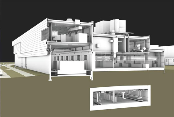
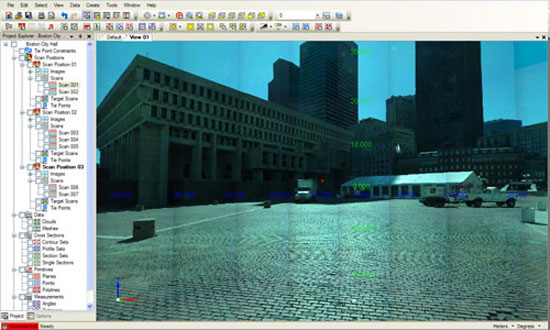
3D laser scanning: 3D laser scanning not only just scan a substantial space and the inner part of a room, but also generates exact information concerning jobsite which in turn facilitates the building information modeling (BIM) process. BIM relies on semantics and necessitates proper information to initiate more far-reaching 3D modeling. Superior 3D laser scanning can convey this powerful feature into BIM.

It is assumed that 3D, BIM and Cloud are all closely inter-linked with each other and 3D laser scanning represents this connection by initially recording the facade and shape of a structure and subsequently converts all those information into cloud enabled data points in order to import them for producing a BIM model.

Although a 3D laser scanner is quite expensive but it is indispensable for real estate industry and realtors can increase their ROI to a great extent by using 3d laser scanner. Besides, 3D laser scanning may also motivate the realtors to search for domains.

Cloud-supported data management: Now-a-days, data management tools are generally compatible with cloud and can be applied to deal with data via cloud. All the stored data should be transferred from local computer to cloud. The designers and architects can improve their design ideas as well as make them logical through incorporated 3d models. Besides they can also interact with 3d models more efficiently.

Cloud platforms can streamline the collaboration process significantly as they allocate the data for being used in diverse ways. The models created through cloud are based on raw data. There are also various tools in cloud which can manage and preserve project data efficiently.

With the Cloud based tools lets, the data is incorporated with a web-page that is HTTPS enabled. One will be able to avail the crucial features as well as accomplish operations on the job site and distribute the outputs with other project stakeholders through the web. Generally cloud-motivated platforms for data management include file-sharing system, hardware controller and web operating system.

Collaboration and consulting: One vital aspect of 3d modeling is to reduce the essential requirement of 3D modeling is eliminating the high-priced phases of collaboration. Usually such phases are long-distance and lingering. As regards to time, it is detected that a single mode of collaboration is useful in suppressing the hindrances to progress. If a distinctive mode of collaboration is undertaken for 3D modeling, then it will help to get rid of duplication, rapid response to modifications and upgrades, etc.

In order to streamline the process, a third party consultant is required to train the whole team so that they are able to get rid of the incorrect & poor quality input and get value to the owner of the building through the 3D models that they are working on.

If all the project stakeholders collaborate with each other and discuss with with those, who know how to overcome the BIM challenges, then 3D modeling would be more methodical, less tedious and less expensive. For the construction and interior decoration industries, it will bring huge benefits.


BIM and Cloud technology become the part and parcel of 3D model based design.
Image Courtesy: bradleybim.com


~~~~~~~~~~~~~~~~~~~

Published By
Rajib Dey
~~~~~~~~~~~~~~~~~~~


Tuesday, December 30, 2014

Some handy BIM/VDC-associated technologies which can make a sea change in AEC Firms

The workflows of AEC firms are improved to a great extent with the implementation of building information modeling & virtual design and construction. Several upgraded techniques emerge out to transform 3d co-ordination process to a superior level.

The followings are some handy BIM/VDC-associated technology trends which facilitate the building team to design, build as well as operate buildings efficiently in the future course of time.

3D laser scanning: Lots of softwares contain less expensive field scanning techniques which perform through BIM models having perfect field information for construction sites. A scan is performed through the strong laser recording of the building structure that gathers the shape and look of a site. These conditions are transformed into a cloud of data points which are imported into a BIM model.

On a solo project, 30 minutes of scan time in the jobsite and 30 minutes of post-processing and uploading the point cloud into a Revit model can lead to saving of $30,000.

Model energy performance on the fly: With the emergence of new software tools, energy analysis of a building is executed throughout the conceptual design stage. Autodesk and Sefaira have launched various applications facilitating designers to accomplish energy study of early concepts on the fly. These applications compact the time required for assembling and crunching energy performance data for a long period. It facilitates the design teams to adapt their designs on the fly on the basis of the data.

Prefabrication will transform building delivery: Several Building Teams are applying BIM methods to collude with general contractors and construction managers to prefabricate and set up building components which range from mechanical equipment, plumbing infrastructure, and even complete restroom pods.

BIM makes the prefabrication process easy and smooth as the design become constructible in the model to be prefabricated and installed.

Data management: Some leading software companies like Assemble Systems and Panzura have built up cloud-based devices to manage, preserve, and distribute project data in a sophisticated way.

Computer-aided manufacturing: With the arrival of prefabrication and manufacturing processes like Lean construction, it opens savings and process efficiencies, the AEC are compelled to comply much the identical way computer-aided manufacturing changed manufacturing. Various CAM technologies together with BIM processes can deliver ready-to-install modules.

Some handy BIM/VDC-associated technologies which can make a sea change in AEC Firms
Image Courtesy: www.bdcnetwork.com

Ref.: http://www.bdcnetwork.com/

~~~~~~~~~~~~~~~~~~~
Published By
Rajib Dey
~~~~~~~~~~~~~~~~~~~

Tuesday, July 15, 2014

Topcon introduces cloud based ScanMaster v3.0 compatible with BIM

Topcon Positioning Group launched the most updated version of its laser scanner software package alias ScanMaster v3.0.

ScanMaster consists of tools for accumulating, processing, editing and distributing 3D point cloud data from a laser scanner for diversified applications. By integrating the Topcon GLS family of laser scanners, with ScanMaster software, one can get complete BIM (building information modeling) environment functionality.

ScanMaster system comes with a cloud-to-cloud registration solution that facilitating improving field and scanning workflows.

ScanMaster v3.0 allows practitioners, who apply third-party scanners, to enjoy the superior quality workflow as compared to Topcon GLS customers.

The improved cloud-to-cloud registration ability can considerably reduce the requirement to set targets — even in the most complicated work situations. This feature can also expands the well-organized application of 3D laser scanners that range from mining deformation projects and accident reconstruction applications — where the placing of targets are considered as a factor of safety.

ScanMaster facilitates the professionals in a wide array of fields to accumulate point cloud data efficiently, then develop and generate final deliverables.

ScanMaster v3.0 alos contains some added features like FARO file import options, ASTM E57 file import and export operations, point cloud library (PCD) file import and export functionality, cleanup and region selection tools, volume calculation and automatic edge set extraction.

Topcon introduces cloud based ScanMaster v3.0 compatible with BIM

~~~~~~~~~~~~~~~~~~~
Published By
Rajib Dey
www.bimoutsourcing.com
~~~~~~~~~~~~~~~~~~~

Wednesday, November 20, 2013

Trimble’s 3D BIM consulting services are useful for MEP contractors

Trimble just introduced 3D BIM Consulting Services. These services are designed for Mechanical, Electrical and Plumbing (MEP) contractors who utilize Computer Aided Design (CAD) and Building Information Modeling (BIM) aptitudes.

Trimble's services will cover four elements ranging from 3D Model Evaluation, 3D Modeling, 3D Laser Scanning and 3D Modeling from Scanned Point Cloud.

MEP contractors apply BIM to get cost saving advantages toward pre-planning, prefabrication, value engineering and coordination together with other contractors. Trimble's consulting service model will facilitate the MEP contractor to integrate with the Trimble MEP 3D BIM Consulting Services team to develop the skills as well as reduce the technological differences with quick scalability.

Under 3D BIM Consulting Services, one individual project manager from Trimble, will supervise every consulting project. He will perform in a manner to make the bridge connecting the subcontractor and the team of 3D BIM modelers and subject matter experts inside Trimble's MEP Division.


By collaborating with MEP contractors and their BIM/CAD departments, Trimble will get the ability to increase their accessible resources and offer services for projects having different sizes. Thus clients will acquire a complete in depth building systems design from Trimble.

Trimble's 3D BIM Consulting Services for MEP contractors are available now. Details and contact information are located at: MEP.Trimble.com/services

~~~~~~~~~~~~~~~~~~~~~~~
Submitted by Rajib Dey
Content Writer


Wednesday, May 30, 2012

Indoor - Mobile Mapping System for Laser Scanning

The latest technology in laser scanning is MOBILE MAPPING. With this technology one can scan while moving. This feature of the system saves lots of time on scanning and maintains accuracy during the geospatial data collection. MOBILE MAPPING SYSTEMS (MMS) has made a revolution in the indoor scanning market. Mobile Mapping System contains LiDAR-based SLAM technologies that remove the penetration problems particularly with interiors of buildings.

Indoor Mobile Mapping System known as I-MMS contains integrated 3D laser scanning & digital Imagery and facilitates the user to scan, map, and accumulate a entire 3D pointcloud.


Friday, April 27, 2012

How BIM facilitates modeling of infrastructure projects


BIM was frequently applied with commercial and residential buildings. But  in recent years BIM (Building Information Modeling) process and technology is utilized in major infrastructure projects ranging from roads & highway, bridges, dams, water treatment facilities, power plants, transportation facilities, transit, airport projects,   utilities (such as gas, electric, water and wastewater) etc. As for example , the design and construction of the Harbour Way Port Talbot project in Wales, that contains rail and roadwork to join the M4 into Port Talbot and the docks.

Within 2014 the application of BIM for infrastructure projects is going to increase more than 50% as BIM with its digitally-based internal and external collaborative processes offers greater productivity as well as improve efficiency and costs. 

67% of current users of BIM for infrastructure experience a positive ROI on their BIM investments whereas over 40% of the users identified as experts in BIM application for infrastructure experience an ROI of 50% or greater.

BIM contains an intelligent, model-based process in which all the data or information is integrated in a workable model.  City planners, GIS professionals, and civil engineers get the project insights instantly  and create cost effective infrastructure projects. Besides, the users can generate 3D model of entire infrastructure including urban environment, ground infrastructure from accessible BIM data &  import detailed models and create 3D thematic maps.

Data within a BIM model can provide information on utility lines, direction of waterflow, pipe materials, elevations and slopes, connectivity. The model can also contain the date of pipe installation and inspection. This will facilitate to find out the possible trouble areas and improvement areas in a more convenient ways.

3D modeling plays an important role for infrastructure project from planning through lifecycle management. A variety types of data is accumulated and incorporated in layers as well as X,Y, and Z coordinates, geographic information system (GIS) data, parcel boundaries, and aerial photographs. Obtainable roads and buildings and utilities are placed into the model. Detailed analysis is achieved with the formation of the model. Analysis happens simultaneously with design, not post-design.  Additionally, data and relationships are predictable for the future.

BIM is also being utilized to examine geometry, spatial relationships and geographic information, quantities and properties of construction components. Besides, the project team employs sensor measurement and control signals to further evaluate the operation and maintenance of infrastructure.

BIM also provide great benefits for infrastructure projects toward prefabrication and modularization by improving productivity factors ranging from schedule, cost, quality, sustainability and safety. 

BIM also assist to minimize inconsistencies and changes, enhance project quality, reduce project risk, better predictability of project outcomes for infrastructure projects.

Latest innovation in Laser scanning technology with aerial Light Detection and Ranging (LIDAR) can capture data, geometry, and characteristics precisely and rapidly from infrastructure assets. This data can be incorporated with a BIM model or workflow to produce rich data sources producing an as-built model of existing infrastructure to be useful for designers to visualize & simulate the performance, appearance and cost of renovations. Project stake holders can formulate informed decision to walk around design alternatives, associated structural performance analyses, seismic audits, and cost and schedule visualizations.  

BIM based digital model comprises of data components symbolizing infrastructure elements like materials, weight, loading resistance, and other physical properties that lead to seismic performance and cost or schedule parameters. Utilizing BIM in infrastructure projects the users get the ability to evaluate and study the performance of individual components and assess, compare, and grade the environmental and financial impact of anticipated renovations for an total system. 

BIM features 3D visualization, simulation and analysis to examine numerous design alternatives in advance in the process and deliver more durable infrastructure in future.


BIM empower all the project team members to watch the model of the project from different angle enhancing the communication among the entire project team. 

Some useful software for infrastructure modeling :-
  • Autodesk Infrastructure Modeler 2012 
  • AutoCAD Utility Design 2012
  • Autodesk Civil 3D  
Posted by
Rajib Dey
Visit us at www.bimoutsourcing.com for more information

Thursday, November 17, 2011

BIM and 3D laser scanning


3D Laser scanning is the process that generates highly accurate location information to produce uniformly precise 3D models which later on can be utilized to repair, renovate, estimate the need for structural upgrade or seismic retrofitting, design visualization and optimize our infrastructure for a more sustainable future. So the progression of adapting old structures for new purposes or “adaptive reuse” in view of the current economic climate and sustainability efforts is possible with 3D laser scanning.

3D laser scanning provide detailed modeling or information for modeling and any development, any addition, virtually any view situation or impact, any re-creation or any topography impact can be prepared digitally.

The level of detail and the completeness that in many cases only laser scanning can provide.

Now-a-days laser scanning combined with a BIM-centric process can support a building’s entire life cycle to a great extent. It develops resource efficiency of buildings, which is a basis of sustainability efforts today. The architect and engineers armed with this complete model can now create improved informed intervention early on the design stage and provide a real impact on design decisions for the future of the building or other infrastructure. Long term facility management systems can be arranged for future maintenance and upgrade projects.

Laser scanning can be applied to support the detailed documentation of the as-built to instigate a facilities program for the long-standing management of an asset. 3D laser scanning facilitates the provision for quick, precise as-built data of large, complicated, and often dilapidated buildings and their supporting infrastructure (water pipes, sewers, drainage, etc.). The as-built data is utilized for planning and design process mainly where sustainability and reprocess of existing infrastructure become an important factor in areas like energy refits. Designers are able to evaluate the prospective reuse of buildings as well as understand the original construction.

In a historical preservation project exclusive of laser scanning it is not possible to assure that the contractor is deliver the desired product.


By applying laser scanning combined with a BIM-centric process mechanical, electrical, and plumbing (MEP) spaces within the facility can be scanned and documented from several vantage points. These 3-D laser scans contained all accessible facilities and installed components as well as mechanical, electrical, and plumbing fit-outs; air handling duct work; and structural ladders, catwalks, and platforms.

The scanner accumulated raw data of all elements in the facility in the form of a dense 3-D spherical point cloud made up of millions of 3-D coordinates. In the end, these 3-D laser images formed a high-definition survey within the facility. After the completion of the scan, the scanning images are brought into BIM software by means of the Pointools plug-in to generate engineered geometry-based models.

Tools for 3D Data Capturing
Low cost survey:
  • Laser Disto
Surveying :
  • Robotic total station
3D Imaging, Laserscanning :
Upcoming technologies :
  • Photogrammetry
  • – Dense image matching
  • Vision SLAM
  • – via smart mobile device or UAV helicopter
  • Range Cameras
  • – E.g. PrimeSense, Microsoft

Useful links
http://www.comitproject.org.uk/downloads/events/construction_mobileit_2011/Capturing%203D%20Geometry%20for%20BIM.pdf
http://www.leica-geosystems.com/media/new/product_solution/BIM_and_Laser_Scanning_The_American_Surveyor_072009.pdf


Posted by Rajib Dey
Business Development
rajib@jobs2india.com
Global Associates (Pioneer Company in 3D modeling with BIM & Sketchup)

visit our BIM sites