adsense analytic

Showing posts with label visualization. Show all posts

Friday, July 12, 2019

Microcenter Group and Autodesk to make Partnership to offer training on BIM and CAD

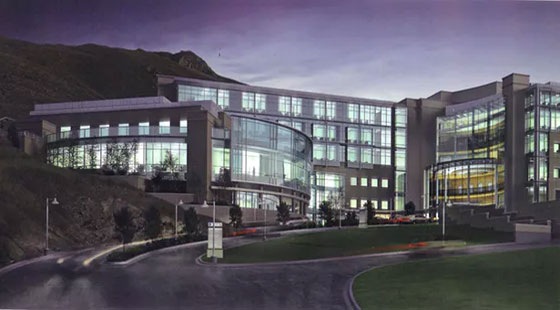
MicroCenter Group ties a knot with Autodesk to provide advance education on Autodesk design application, BIM and CAD.

Renowned information technology solutions company MicroCenter Group has officially declared its academic joint venture with Autodesk.

The program will facilitate the formation of an Autodesk authorised learning centre, Design BIM Studio, and Certiport authorised test centre.

The purpose of this alliance is to reanalyze advanced education and work skills in Autodesk design applications, 2D and 3D CAD designs, infrastructure designs, building information model (BIM) and BIM co-ordination, 3D model and real-world visualization.

The collaboration provides more value to industry professionals who will opt for advanced education on Autodesk software applications through the Micro Training Center (MTC), a subsidiary of MicroCenter Group.

Courses will be conducted on AutoCAD, AutoCAD-Civil 3D and Map 3D, AutoCAD–Plant 3D, Revit Architecture, Revit MEP and Structural, Navisworks, Inventor, 3DS Max, Fusion 360 and Maya and Autodesk professional certification.

MicroCenter Special Projects Business and MTC will set up BIM design and BIM Education centre this year, to provide complete building information modelling and implementation services through the 3D laser scanning technology, for building, infrastructure and metro-rail projects.

BIM studio will arrange advanced and professional skills training to engineers, architects, industry professionals, educators, and students.

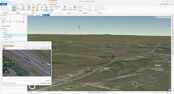
Esri and Autodesk work in tandem to mutually provide GIS and BIM across multi-disciplinary teams and project life cycles.

The objective is to maintain an integrated and collaborative workflow that progresses understanding of projects within the framework, and minimizes inefficiencies, data loss, and cycle times.

Designers and engineers will be able to get GIS content from ArcGIS Online into Infraworks via the Autodesk Connector for ArcGIS.

Content such as roads, pipelines, and electrical transformers will be directly imported depending on an authoritative, subsisting geographic system of record.

Read more

Microcenter Group and Autodesk to make Partnership to offer training on BIM and CAD

~~~~~~~~~~~~~~~~~~~~~~~~
Published By
Rajib Dey
www.bimoutsourcing.com
~~~~~~~~~~~~~~~~~~~~~~~~

Thursday, June 20, 2019

A position is vacant for BIM Studio Manager in San Diego, Phoenix or Culver City offices

Cuningham Group, a leading architecture firm with 8 offices around the world, is inviting applications for the position of a BIM Studio Manager in San Diego, Phoenix or Culver City offices. This position can be filled in any of the three locations and all openings are posted separately on our website. The prospective candidates should posses two years of experience with a special emphasis on the projects for healthcare facilities along with acute care and outpatient services.

Skills and ability:

1. Set up BIM 360 project sites.
2. Guide project teams as it pertains to BIM production as a priority function.
3. Train and implement BIM best practices and firm wide standards.
4. Ensure compliance and delivery of services indicated in the project BIM Execution Plan.
5. Organizes archiving project files at project milestones and close-out.
6. Organizes and provides training on advanced functions like clash detection, visualization, reality capture, etc.


Professional Experiences:

1. Associates Degree or higher with a specialization in BIM, Architecture, or Construction.
2. Outstanding knowledge with Revit.
3. Insight into Autodesk BIM 360 preferred platform.
4. Understanding of dealing with large multiple model Revit projects.
5. Sound problem solving/analysis, and technical strength to research and employ building codes.
6. Excellent oral and written communication skills.
7. Sound task-oriented time management.
8. Hold proven teamwork abilities and perform efficiently in an open office environment.

9. Capability to travel periodically.

The interested candidates can submit a resume, portfolio and cover letter specifying their experience to joinus@cuningham.com

Read more

A position is vacant for BIM Studio Manager in San Diego, Phoenix or Culver City offices

~~~~~~~~~~~~~~~~~~~~~~~~
Published By
Rajib Dey
www.bimoutsourcing.com
~~~~~~~~~~~~~~~~~~~~~~~~

Wednesday, June 12, 2019

A position is vacant for Job Captain/Designer in Log Angeles, US

General Description: Studios Architecture is globally recognized for unique and creative design; for master planning, architecture and interior design projects. The firm is inviting application for the position of job captain/designer having 3 to 7 years of working experiences.
Skills :-
1. Complicated, large-scale projects
2. Technology and sustainability integrated design
3. The power of design and the social role of architecture over an extensive range of project types along with commercial office, mixed-use, academic and civic institutions.
4. The designers should have the ability to provide support at different project scales and phases of project development.
Qualifications /Responsibilities:
1. Bachelor’s degree in Architecture or Interior Design required.
2. Sound portfolio is necessary with professional and academic projects indicating intelligent, innovative design conceptualization, professional caliber visualization and presentation graphics, along with experience in construction documentation.
3. Three to Seven years of working experience in an architectural or interior design firm are necessary. Experience in extremely complex project types, large commercial office, mixed-use, civic, academic, and/or cultural projects is preferred.
4. Capability to head smaller projects alone as well as co-operate e on larger-scale projects as part of a team. Ability to work efficiently, equalize demands on numerous projects at different phases of development.
5. Sound communication skills and capability to collaborate internally (with team) and externally (with clients, consultants, contractors, and vendors) is necessary.
6. Knowledge with all stages of Architectural services from Schematic Design through Construction Documentation and Construction Administration is required.
7. “Can Do” attitude with outstanding analytical, problem-solving, and presentational skills is necessary.
8. Design and documentation experience with Revit is solicited. Experience with Revit, Rhino, Autocad, Grasshopper, and Sketch-up are essential.
9. Licensure/LEED Accreditation or pursuit of licensure and LEED accreditation is desired.
Apply online archinect.com
A position is vacant for Job Captain/Designer in Log Angeles, US
~~~~~~~~~~~~~~~~~~~~~~~~
Published By
Rajib Dey
www.bimoutsourcing.com
~~~~~~~~~~~~~~~~~~~~~~~~

Tuesday, May 29, 2018

Esri is introducing ArcGIS Pro 2.2 Beta with improved BIM and Revit features

The Esri is going to introduce ArcGIS Pro this summer. It will provide direct reading capabilities for Autodesk Revit in order that BIM information is delivered into the ArcGIS platform’s workflows.

This capability will be available for ArcGIS Pro 2.2. Till now, ArcGIS Desktop can read BIM information through Industry Foundation Classes (IFC) files. It is accomplished with the Interoperability Extension, a plugin for data conversion.

The usefulness of BIM data for GIS users

By applying new Revit reading capability, GIS users can perform two things. First of all, they will be able to visualize BIM information in ArcGIS Pro, storing the semantically structured information from Revit via feature classes, which are collections of map presented in a GIS. It allows them to apply the features they need from the data model for other purposes like asset management.

Secondly, a complete BIM model is visualized in a geographic context. This visualization strength will provide more transparency to GIS users concerning what´s inside a BIM model. Similarly, it is also vital to learn what´s not inside a BIM model, as for instance rooms and spaces—both belong to geometric entities well-known with the GIS world and applied for analysis, but not intended for the architects.


Since Revit provides a limited amount of categories, these are all mapped to a feature class to give entry to all related attribute and parametric information. IFC, in comparison, employs various categories which are complicated to control in a GIS.
Esri manages Revit data within ArcGIS by extracting the data and interpreting it as a GIS dataset. ArcGIS can export feature classes into .dwg format that can be obtained in AutoCAD with a plugin known as ArcGIS for AutoCAD. The Revit read capability is a first step in a same process for BIM data.

To get more detail, go through the following link www.esri.com
Esri is introducing ArcGIS Pro 2.2 Beta with improved BIM and Revit features


~~~~~~~~~~~~~~~~~~~~~~~~
Published By
Rajib Dey
www.bimoutsourcing.com
~~~~~~~~~~~~~~~~~~~~~~~~

Friday, April 27, 2012

How BIM facilitates modeling of infrastructure projects


BIM was frequently applied with commercial and residential buildings. But  in recent years BIM (Building Information Modeling) process and technology is utilized in major infrastructure projects ranging from roads & highway, bridges, dams, water treatment facilities, power plants, transportation facilities, transit, airport projects,   utilities (such as gas, electric, water and wastewater) etc. As for example , the design and construction of the Harbour Way Port Talbot project in Wales, that contains rail and roadwork to join the M4 into Port Talbot and the docks.

Within 2014 the application of BIM for infrastructure projects is going to increase more than 50% as BIM with its digitally-based internal and external collaborative processes offers greater productivity as well as improve efficiency and costs. 

67% of current users of BIM for infrastructure experience a positive ROI on their BIM investments whereas over 40% of the users identified as experts in BIM application for infrastructure experience an ROI of 50% or greater.

BIM contains an intelligent, model-based process in which all the data or information is integrated in a workable model.  City planners, GIS professionals, and civil engineers get the project insights instantly  and create cost effective infrastructure projects. Besides, the users can generate 3D model of entire infrastructure including urban environment, ground infrastructure from accessible BIM data &  import detailed models and create 3D thematic maps.

Data within a BIM model can provide information on utility lines, direction of waterflow, pipe materials, elevations and slopes, connectivity. The model can also contain the date of pipe installation and inspection. This will facilitate to find out the possible trouble areas and improvement areas in a more convenient ways.

3D modeling plays an important role for infrastructure project from planning through lifecycle management. A variety types of data is accumulated and incorporated in layers as well as X,Y, and Z coordinates, geographic information system (GIS) data, parcel boundaries, and aerial photographs. Obtainable roads and buildings and utilities are placed into the model. Detailed analysis is achieved with the formation of the model. Analysis happens simultaneously with design, not post-design.  Additionally, data and relationships are predictable for the future.

BIM is also being utilized to examine geometry, spatial relationships and geographic information, quantities and properties of construction components. Besides, the project team employs sensor measurement and control signals to further evaluate the operation and maintenance of infrastructure.

BIM also provide great benefits for infrastructure projects toward prefabrication and modularization by improving productivity factors ranging from schedule, cost, quality, sustainability and safety. 

BIM also assist to minimize inconsistencies and changes, enhance project quality, reduce project risk, better predictability of project outcomes for infrastructure projects.

Latest innovation in Laser scanning technology with aerial Light Detection and Ranging (LIDAR) can capture data, geometry, and characteristics precisely and rapidly from infrastructure assets. This data can be incorporated with a BIM model or workflow to produce rich data sources producing an as-built model of existing infrastructure to be useful for designers to visualize & simulate the performance, appearance and cost of renovations. Project stake holders can formulate informed decision to walk around design alternatives, associated structural performance analyses, seismic audits, and cost and schedule visualizations.  

BIM based digital model comprises of data components symbolizing infrastructure elements like materials, weight, loading resistance, and other physical properties that lead to seismic performance and cost or schedule parameters. Utilizing BIM in infrastructure projects the users get the ability to evaluate and study the performance of individual components and assess, compare, and grade the environmental and financial impact of anticipated renovations for an total system. 

BIM features 3D visualization, simulation and analysis to examine numerous design alternatives in advance in the process and deliver more durable infrastructure in future.


BIM empower all the project team members to watch the model of the project from different angle enhancing the communication among the entire project team. 

Some useful software for infrastructure modeling :-
  • Autodesk Infrastructure Modeler 2012 
  • AutoCAD Utility Design 2012
  • Autodesk Civil 3D  
Posted by
Rajib Dey
Visit us at www.bimoutsourcing.com for more information

Tuesday, November 1, 2011

Tekla Releases BIMsight 1.3 for imporved collaboration in construction industry

Tekla unveils a new imporved version known as BIMsight 1.3. Tekla BIM is a BIM (building information modeling) environment designated for contractors, structural engineers, steel detailers and fabricators, as well as concrete detailers and manufacturers.

Tekla BIMsight can be shared and downloaded over the internet at free of cost. Tekla BIMsight 1.3 facilitate the project parties to get the appropriate information from the different models and address the feasible issues. With the coloring function options users are able to choose colors for models or model objects, alongwith transparency. The support for layers simplifies the process of filtering the revelant data and the support for units (SI and Imperial) keep the information easily understandable.

The latest version will empower the Tekla BIMsight users to exchange notes in open BCF format and this will enhance the collaboration phase to a great extent. Tekla launched first version of this unique software application for building information model-based construction project collaboration in February 2011.

Tekla BIMsight has been successful in the form of a rapidly increasing user base of construction professionals and favorable reviews. Tekla provides most sophisticated BIM tool to be applied with any construction project and reap the benefits of timely project delivery and fewer RFI's.

Tekla BIMsight can be applied for design coordination in all BIM projects varying from big and small.


Download Tekla BIMsight 1.3 software for free here.
Any body can get help from a unique Video tutorials and an online customer community for visualizing and communicating with building information models.

Posted by Rajib Dey
Business Development
rajib@jobs2india.com
Global Associates (Pioneer Company in 3D modeling with BIM & Sketchup)

visit our BIM sites
www.bimoutsourcing.com
www.bimcoordination.com